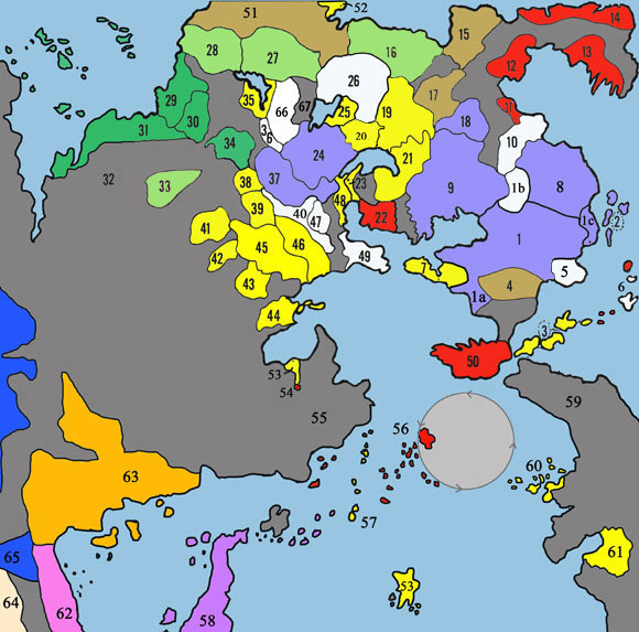
- Ahlissa (Southern Kingdom)
1a Former Idee (conquered country)
1b Adri Forest (elves and fey)
1c Rel Astra and the Solonor Compact
- Sea Barons
- Lordship of the Isles
- Sunndi
- See of Medegia (Undead country)
- Lendor Isles (Elven occupied)
- Ironwall (Including former Onnwal)
- Andoria (North Kingdom)
- Nyrond
- Bone March
- Ratik
- Frost Barbarians
- Snow Barbarians
- Ice Barbarians
- Stonehold
- Rovers of the Barrens
- Tenh
- Pale
- Bandit Kingdoms
- Shield Lands
- Urnst (County and Dutchy)
- Bright Lands
- Greyhawk, Free City
- Furyondy
- Bone March
- Empire of Iuz
- Wolf Nomads
- Tiger Nomads
- Ekbir
- Tusmit
- Zeif
- Plains of the Paynims
- Ull
- Ket
- Perrenland
- Highfork (Elves and gnomes)
- Archprelacy of Veluna
- Bissel
- Gran March
- Lortmil Mountains (Dwarf Confedreacy)
- Geoff
- Sterich
- Yeomanry
- Sea Princes
- Keoland
- Ulek (Duchy, County, Principality)
- Celene (High & Grey Elves)
- Dyvers & the Wild Coast
- Pormarj (Orcs & Goblinoids)
- Scarlett Brotherhood
- Hepmonaland Jungle
- Amedio Jungle
- Sasserine
- Cauldron
- Blackmoor
|
|
- Yellow - Common
- Blue - Oerdian
- Red - Suel
- Light Green - Flan
- Deep green - Baklunish
- Brown - Paynims
- Purple - Uli
- White - Nonhuman
- Grey - Wilderness
|

